Rockcastle County was formed in 1810 from portions of Lincoln, Madison, Knox and Pulaski counties. The fifty-second county established in Kentucky, it has an area of 318 square miles. The county shares the name of the Rockcastle River, named by explorer Isaac Lindsey in 1767, for the towering rock formations along the stream, which resemble castles. The eastern portion of the county went into the formation of Laurel County in 1825, making the river a boundary. Legislative action in 1972 included the Rockcastle River in the Wild Rivers System of Kentucky. Other waterways include the Dix River and Boone's Fork.
 About one-fourth of the county is part of the Daniel Boone National Forest. The western edge of the Knobs region, a transitional area surrounding the Outer Bluegrass, covers about two-thirds of the county and the terrain is quite rugged. Narrow valleys, huge boulders, steep hillsides and swift winding creeks make the county difficult to traverse; indeed, in the 1820 census, enumerators were unable to reach some sections of the county. The official census report included a note by Sheriff William Grisham, who explained that the "mountainous and rugged county" made the census enumeration "as hard a task and perhaps more so than any county in the state." Confederate General Felix Zollicoffer, in an October 1861 report to the adjutant general's office, referred to the Union's position on Rockcastle Hills as an "entrenched camp, a natural fortification, almost inaccessible.
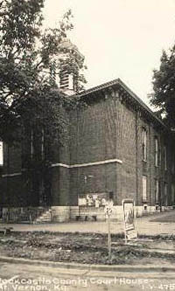
Settlers from the east passed through what is now Rockcastle County along Boone's Trace, Skaggs' Trace or the Wilderness Road. Tradition holds that Stephen Langford led the first settlers into the county and founded Mt. Vernon, the county seat, in 1790. The original log courthouse burned in 1873, destroying official records. The other incorporated towns are Brodhead, since 1885 the site of the "Little World's Fair" in the western part of the county, and Livingston, on the Rockcastle River. Between Mt. Vernon and Livingston is Pine Hill, which in 1873, during its height as a coal and lumber town, had a population of six hundred, but the community now numbers only a handful of residents.
The earliest industry was the extraction of saltpetre from the Great Saltpetre Cave for manufacturing gunpowder. The cave lies in the southeastern section of the county, north of Livingston, and most easily reached via KY 1004. The cave was a shelter for both Confederate and Union troops during the Civil War. The Battle of Camp Wildcat, or Battle of Rockcastle Hills, was fought in October 1861 across the Rockcastle River, in Laurel County.
Settlers in the county were sparse until the advent of the railroad in the latter part of the nineteenth century. The Louisville & Nashville Railroad reached Brodhead and Mt. Vernon in 1868. In 1870 Livingston became the terminus of the railroad and remained so until 1882, when the rails were extended to London, in Laurel County. The Kentucky Central Railroad reached Livingston two years later (1884). Coal in Livingston and Pine Hill was of exportable quality. Lime, building stone, barrel staves, and tannin bark were also shipped by rail. These developments pushed the population from 5,343 in 1860 to a peak of 17,165 in 1940.
The county's first newspaper, the Mountain Signal, was published in 1887. It later became the Mountain Eagle and is now published as the Mount Vernon Signal. The earliest compiler of historical notes about the county was Colonel James Maret, founder and editor of the Mountain Signal: his material was published only in the newspaper. An engineer by training, Maret pushed for paved roads in the state to "open the mountains to civilization." Maret wrote his "Notes and Clips" column until his death in 1936.
Renfro Valley, probably the best-known area of Rockcastle County, was the home of John Lair, who started national radio broadcasts of the "Renfro Valley Barn Dance," a country music program, in November 1939. The county's only radio station, WRVK 1460am, is located in Renfro Valley. Lair also chronicled the county in his Mount Vernon Signal column, "Rockcastle Recollections," from 1972 to 1974.
From 1835 to the early 1900s, the Rockcastle Springs Hotel located about 5 miles from the mouth of the Rockcastle River, was a popular summer resort. A community of homes located around Lake Linville was formed in the early 1970s along I-75 near Renfro Valley.
Rafting along the Rockcastle and through the narrows, a mile and a half of white water, is popular. Tourism and agriculture are the economic backbones of the county. There are some isolated industries in the county's three incorporated towns. Transportation routes include US 25, US 150 and I-75. The Daniel Boone Parkway is accessible 22 miles southeast, while the Cumberland Parkway is accessible 26 miles southwest. The population of the county was 12,305 in 1970; 13,973 in 1980; 14,803 in 1990 and an estimated population of 15,744 in 1997.
J. Allen Singleton